Enhancing Autonomous Vehicle Reliability with Multi-GNSS Antenna Configurations
Reliability in an autonomous vehicle is decided before the navigation filter ever runs. It is decided by how many independent views of the sky the vehicle has, and by whether heading is measured directly or inferred from motion. A multi-GNSS antenna configuration changes both variables at the same time.
A single antenna feeding a single receiver produces one position solution — and, when the vehicle is stationary, no usable heading at all. Adding a second antenna on a known baseline converts the same satellite signals into a measured heading, a redundancy layer, and a cross-check that can flag interference or spoofing. For integrators building autonomous platforms for ports, agriculture, rail and on-road vehicles, that difference determines whether the platform keeps operating when the environment degrades.
Shenzhen Jumpstar Technology Co., Ltd. (JUMPSTAR CO., LIMITED) is a GNSS positioning manufacturer founded in 2013 and headquartered in Shenzhen, China, producing RTK modules, GPS and GNSS antennas, GNSS receivers and smart antenna modules for global integrators. Roughly 70% of its output is exported to the EU, USA and Middle East. The building blocks referenced in this guide — multi-band RTK positioning and heading smart antenna modules, heading-capable RTK modules, IMU-integrated RTK receivers and multi-band helical antennas — form the hardware layer of the configurations described below. Product details are available at www.jgnss.com.
Problem Definition: The Failure Modes a Single Antenna Cannot Cover
Autonomous vehicle GNSS integration planning typically separates four risk classes: RF electromagnetic interference, satellite signal spoofing, vehicle environment failure, and navigation data security.
- RF electromagnetic interference: broadband, narrowband and pulsed RF noise generated by vehicle engines, onboard electronics and external portable jamming devices can obscure satellite signals, producing RTK floating solutions, positioning drift, or complete loss of satellite lock.
- Satellite signal spoofing: man-made forged GNSS navigation signals can tamper with vehicle position coordinates, disrupting autonomous driving and special vehicle control operations.
- Vehicle environment failure: long-term vehicle vibration, jolting, extreme temperatures and high humidity can cause hardware malfunctions and degraded positioning accuracy.
- Navigation data security: differential data and raw observation trajectories are vulnerable to interception and tampering during transmission or storage, potentially exposing vehicle geographic information.
A single-antenna, single-receiver architecture exposes the vehicle to all four classes through one path. If that antenna's sky view is blocked by a container, a bridge, a building or the vehicle's own superstructure, the receiver loses observables that no filter can reconstruct. If a jamming source raises the noise floor across the band, every satellite the receiver still tracks is degraded simultaneously, because they share one antenna and one RF front end.
The second limitation is more subtle and more dangerous in low-speed autonomy. Heading derived purely from motion vectors becomes undefined or noisy when the vehicle is stopped or creeping — exactly the conditions found in terminal stacking, docking, agricultural headland turns and station approaches. A multi-GNSS antenna configuration solves this geometrically: two antennas separated by a known baseline resolve which way the vehicle is pointing while it is completely stationary, and additional antennas extend that from a single heading vector into a spatial consistency check across the whole vehicle body.
Industry Background: Where Multi-Antenna High-Precision GNSS Solutions Fit
Multi-antenna architectures sit inside a market that is expanding faster than the hardware categories around it. The global high-precision GNSS market was valued at USD 7.8 billion in 2024 and is projected to reach USD 20.6 billion by 2033, according to Dataintelo. The narrower high-precision GNSS module segment was estimated at USD 1.5 billion in 2024 and forecast to reach USD 4.5 billion by 2035, per Market Research Future. At the service layer, EUSPA forecasts GNSS downstream market revenues will reach €580 billion by 2034.
Two technology shifts explain why antenna configuration, rather than receiver accuracy alone, has become the integrator's differentiator. The first is that free correction accuracy has improved: Galileo High Accuracy Service (HAS) delivers horizontal accuracy down to 20 cm, which is enough for many autonomy tasks without a local base station. The second is inertial coupling at the module level — Trimble launched the R12i GNSS System in 2024, integrating IMU technology for enhanced RTK performance, and the mid and high-level precision GPS receiver market is led by Trimble, Hexagon AB, Topcon and Hemisphere GNSS, according to Mordor Intelligence.
As correction accuracy becomes commoditized and IMU fusion becomes standard, the remaining engineering leverage moves to the antenna layer: how many antennas, where they are mounted, how their signals are combined, and how the system behaves when one of them is compromised. Agriculture illustrates the scale of the installed base — it is the dominant application segment for high-precision GNSS with a 36.8% market share in 2025 — and the same multi-antenna logic used on a tractor running controlled traffic patterns transfers directly to an autonomous haul vehicle or a terminal tractor.
Detailed Solution: Verified Building Blocks for Multi-GNSS Antenna Configurations
Jumpstar's portfolio covers the full stack required to assemble a redundant, heading-capable high-precision GNSS solution for autonomous vehicles. Each block below is a verified configuration option, not a marketing category.
Measured heading: the multi-band RTK positioning and heading smart antenna
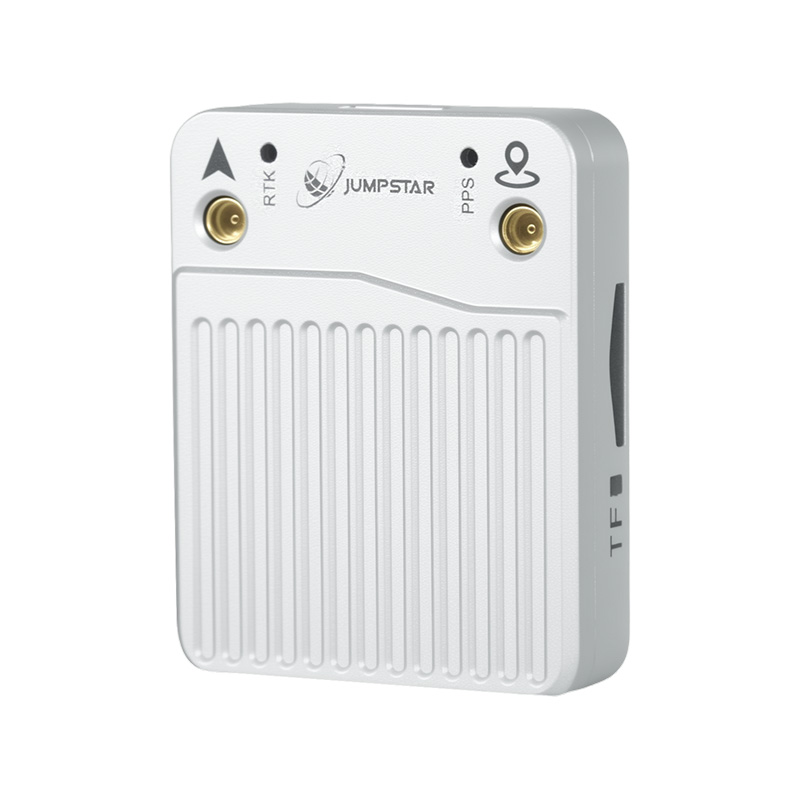
The Smart Antenna model JS-SK43H-AH is a multi-band RTK positioning and heading smart antenna module. It supports BDS, GPS, GLONASS, Galileo and QZSS with 789 hardware channels. Its dimensions are 48.0 mm × 43.2 mm × 37.0 mm ± 0.3 mm and its weight is less than 24 g. For integrators, the significance is integration density: a heading-capable antenna module at under 24 g can be mounted on a roof plate, a roll bar or a mast head without a separate antenna farm, which matters most on space-constrained platforms where roof real estate is already consumed by perception sensors.
Heading-capable RTK modules for distributed antenna layouts
Where the antennas must be spread across a vehicle body rather than co-located, the JS-A56U9D provides the receiver side. It is a high-precision RTK GNSS module for UAV, precision agriculture, autonomous systems and GIS, and it is a multi-band GNSS high-precision receiver supporting GPS, BDS, GLONASS, Galileo, QZSS and SBAS, with 192 search channels and 60 tracking channels. Its dynamic heading accuracy is 0.3 degrees, velocity accuracy 0.05 m/s, velocity limit 500 m/s, and altitude limit 80,000 meters. Time pulse signal accuracy is RMS 30 ns with 99% at 60 ns, and it supports NMEA 0183 V4.11, V4.0 and V4.1, RTCM 3.3 and UBX protocols.
Compact modules for platforms with no spare volume
Volume is the binding constraint on many autonomous platforms, and it is where a distributed antenna architecture usually fails at the bill-of-materials stage. The JS-ARK28-3 is a high-precision RTK GNSS module with a net weight of less than 12.0 g and overall dimensions of 28.0 × 28.0 × 8.0 mm with ± 0.3 mm tolerance. The JS-M6D measures 22.0 mm × 17.0 mm × 2.4 mm and weighs less than 12.0 g, and is intended for applications in UAVs, automotive navigation, smart robots, wearable devices, intelligent logistics, personnel safety IoT, AVL and smart handhelds.
Where slightly more volume is available in exchange for higher channel count, the JS-ANK45-2 is a multi-system multi-frequency high-precision RTK GNSS receiver with 1408 super channels, measuring 45.0 × 45.0 × 12.7 mm ± 0.3 mm and weighing less than 40 g, made of plastic, metal and ceramic. It specifies cold start under 30 s and RTK initialization under 5 s, with positioning accuracy (RMS) of 3D 1.5 m, DGPS 0.4 m + 1 ppm, RTK horizontal 1.5 cm + 1 ppm and RTK vertical 2.0 cm + 1 ppm. It supports NMEA 0183, Unicore and RTCM3.X, operates from −40°C to +85°C, and is RoHS compliant. The JS-ARK37-3 covers a comparable application envelope, listed for UAV/drones, autonomous driving, smart logistics, precision agriculture and location services, surveying and mapping, autonomous robots, in-vehicle applications and precision control.
GNSS + INS coupling: keeping heading alive between antenna updates
Multi-antenna GNSS gives absolute heading; inertial coupling keeps the solution continuous when satellite observables are briefly lost under a canopy or inside a terminal stack. The JS-RK26-U is an RTK GNSS module with IMU designed for automotive navigation and rail transit intelligent positioning. It features dual-band (L1+L5) GNSS+INS integration, tracking sensitivity of −165 dBm, 200 tracking channels and a cold start time of 28 seconds. Speed accuracy is 0.1 m/s CEP and RTK horizontal positioning accuracy is 1.0 cm + 1 ppm. Dimensions are 16.2 × 12.2 × 2.3 mm, net weight is less than 1.1 g, operating range is −40°C to +85°C, and it supports NMEA 0183 and RTCM3.X with a maximum update rate of 20 Hz.
The JS-RP26-U follows the same pattern for automotive navigation and vehicle tracking: a dual-band (L1+L5) GNSS+INS integrated navigation module with tracking sensitivity of −165 dBm, acquisition sensitivity of −148 dBm, single-point horizontal accuracy of 1.0 m CEP and RTK horizontal accuracy of 1.0 cm + 1 ppm, supporting NMEA 0183 V4.1 and RTCM v2.3/v3.3. The JS-TP26-U is used for intelligent driving and vehicle control in automotive navigation, supporting GPS, BDS, GLONASS, Galileo, QZSS and SBAS with single-point horizontal accuracy of 1.0 m (L1+L5) or 2.5 m (L1) CEP and GNSS+INS accuracy under 1.5 m CEP at a 10 Hz maximum update rate.
Antennas that hold lock through multipath and jamming
In a multi-antenna layout, antenna quality sets the ceiling. The helical GNSS antenna model JS-HAC18A-F for UAV applications is a helical active antenna supporting GPS L1/L2/L5, BDS B1/B2, GLONASS G1/G3, Galileo E1/E5a/E5b, QZSS L1/L2/L5, SBAS L1/L5 and IRNSS L5 signals. It provides 360° horizontal coverage, RHCP polarization and 50 Ω impedance — the combination that keeps a distributed antenna ring tracking low-elevation satellites on a moving, tilting platform.
Interference, spoofing and integrity controls
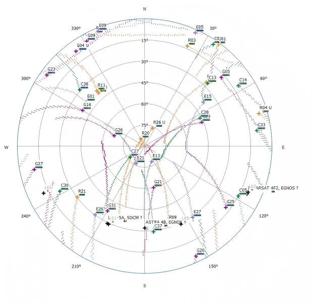
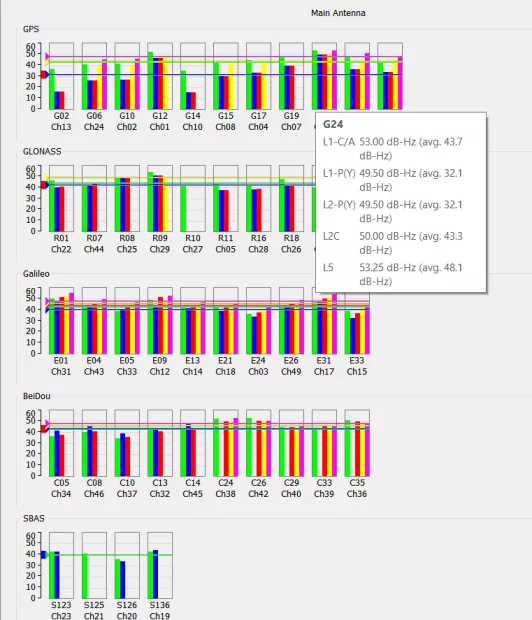
Hardware redundancy only pays off if the receiver can distinguish a degraded antenna from a good one. Jumpstar's interference and integrity layer is implemented as hardware plus algorithm dual risk control. Interference control uses AIM+ full-spectrum interference suppression algorithms with built-in automatic wideband noise reduction, triple-channel adaptive narrowband notch filters and APME multipath mitigation technology to filter electromagnetic interference from urban environments and vehicle electronics. Spoofing control natively supports Galileo OSNMA navigation message anti-spoofing authentication, with built-in RAIM receiver autonomous integrity monitoring to automatically identify and reject illegal forged satellite signals. Environmental control uses industrial-grade components rated across an ultra-wide −40°C to +85°C range, PCB reinforcement techniques, and a unit that has passed sustained vibration testing. Data security control stores raw observation data in SBF format on a TF card so that trajectories are not exposed in transit.
Turnkey integrated receivers for retrofit and fleet programs
Not every program can absorb an RF design cycle. The P-Box-X10 addresses that gap directly. Compared to alternatives such as the Beitian UM982 RTK Board/Module, its core difference is a turnkey integrated receiver versus a bare core component. It provides 80% shorter deployment time and 40% lower total project R&D cost, with comparable power consumption (under 3 W) but better anti-interference stability in harsh RF environments. Maintenance is plug-and-play with remote OTA updates, eliminating the need for an RF engineer. It is more suitable for port logistics, precision agriculture and heavy-duty vehicle retrofitting scenarios.
Step-by-Step Breakdown: Specifying a Multi-Antenna Architecture
The following sequence is the order in which architecture decisions constrain each other. Changing an earlier step invalidates the later ones, so it is worth running in this order on any new autonomous vehicle GNSS design.
- Fix the heading requirement before the accuracy requirement. Decide whether the vehicle needs true heading at standstill and at crawl speed. If yes, a single antenna with GNSS+INS is insufficient for the standstill case and a dual-antenna baseline becomes mandatory.
- Map obstruction, not just accuracy. Survey the operational site for canopies, container stacks, tunnels and building shading, then set antenna count so that no single obstruction removes the majority of observables. Antenna count is driven by exposure, not by the datasheet accuracy figure.
- Choose the receiver topology. Co-located heading and positioning on one compact housing points to a smart antenna module such as the JS-SK43H-AH. Spread antennas on a long baseline point to a heading-capable RTK module such as the JS-A56U9D, which specifies 0.3 degrees dynamic heading accuracy.
- Decide how heading and position survive outages. Pair multi-antenna GNSS with GNSS+INS modules — for example the JS-RK26-U at 1.0 cm + 1 ppm RTK horizontal accuracy with a 20 Hz update rate — so the solution bridges short signal losses without falling back to dead reckoning alone.
- Design the RF and integrity layer. Specify wideband noise reduction, adaptive narrowband notch filtering and multipath mitigation (AIM+ and APME), plus Galileo OSNMA anti-spoofing authentication and RAIM integrity monitoring, so that a compromised antenna can be identified rather than trusted.
- Verify environmental and mechanical durability. Confirm the −40°C to +85°C industrial-grade operating range, PCB reinforcement and sustained vibration testing apply to every element in the chain, including the antenna mounts.
- Validate on the bench, then plan lifecycle maintenance. Use RF, thermal and vibration test data plus per-unit factory verification, and adopt OTA parameter hardening so that fielded vehicles can be updated without a site visit.
Use Cases: Scenario-Based Architecture Recommendations
Port logistics and heavy-duty vehicle retrofitting
Terminal tractors and retrofitted heavy vehicles operate in stacked, metallic, multipath-heavy environments and are often upgraded in the field rather than designed from scratch. A turnkey integrated receiver such as the P-Box-X10 fits this profile: deployment time is 80% shorter and total project R&D cost 40% lower than a bare core component approach, with comparable power consumption under 3 W and better anti-interference stability in harsh RF environments, plus plug-and-play maintenance with remote OTA updates that removes the need for an on-site RF engineer.
Space-constrained autonomous platforms
Small autonomous shuttles, delivery robots and inspection platforms rarely have roof area to spare. Here the multi-band RTK positioning and heading smart antenna module JS-SK43H-AH — 48.0 mm × 43.2 mm × 37.0 mm and under 24 g — allows a measured heading solution without a separate antenna array. Where even less volume is available for the receiver, the JS-ARK28-3 at 28.0 × 28.0 × 8.0 mm and under 12.0 g, or the JS-M6D at 22.0 × 17.0 × 2.4 mm and under 12.0 g, keep the architecture viable.
Rail transit and automotive navigation
Rail and on-road platforms need continuity through tunnels and stations. The JS-RK26-U is designed for automotive navigation and rail transit intelligent positioning with dual-band (L1+L5) GNSS+INS integration, 200 tracking channels, a 28-second cold start, 0.1 m/s CEP speed accuracy and 1.0 cm + 1 ppm RTK horizontal accuracy at up to 20 Hz. The JS-TP26-U targets intelligent driving and vehicle control, and the JS-RP26-U targets automotive navigation and vehicle tracking, both at 1.0 cm + 1 ppm RTK horizontal accuracy class in their respective configurations.
UAV and drone integration
The JS-RK40 module is intended for the UAV/drone industry, while the JS-RK26-3 is suitable for UAVs, intelligent logistics scheduling, maritime navigation, the automotive industry and emergency rescue scenarios, with a VCC power supply range of 2.0 V to 3.6 V and V_BACK range of 1.8 V to 3.6 V. For airborne antenna installations, the JS-HAC18A-F helical active antenna provides 360° horizontal coverage with RHCP polarization and 50 Ω impedance across GPS, BDS, GLONASS, Galileo, QZSS, SBAS and IRNSS L5 bands.
Precision agriculture
Autonomous tractors and implements need stable heading through headland turns and slow passes. The JS-ANK45-2 combines 1408 super channels with RTK horizontal accuracy of 1.5 cm + 1 ppm and vertical accuracy of 2.0 cm + 1 ppm, inside a −40°C to +85°C envelope and RoHS compliance, while the JS-A56U9D supplies 0.3 degrees dynamic heading accuracy in a multi-band module rated to a 500 m/s velocity limit.
Comparison Table: Multi-Antenna Architecture Options
The table below compares the architecture paths an integrator can take. Every entry maps to verified product data rather than to a generic capability claim.
| Architecture path | Verified building block | How heading is obtained | Constellation / channel support | Form factor | Typical fit |
|---|---|---|---|---|---|
| Single-antenna GNSS+INS | JS-RK26-U RTK GNSS module with IMU | GNSS+INS fusion; RTK horizontal 1.0 cm + 1 ppm; speed accuracy 0.1 m/s CEP | Dual-band L1+L5; 200 tracking channels; NMEA 0183 and RTCM3.X; 20 Hz max update | 16.2 × 12.2 × 2.3 mm, under 1.1 g, −40°C to +85°C | Automotive navigation and rail transit intelligent positioning |
| Dual / multi-antenna heading smart antenna | JS-SK43H-AH Smart Antenna | Multi-band RTK positioning and heading within one module | BDS, GPS, GLONASS, Galileo, QZSS; 789 hardware channels | 48.0 × 43.2 × 37.0 mm ± 0.3 mm, under 24 g | Space-constrained platforms that still require measured heading |
| Distributed antenna ring with heading-capable module | JS-A56U9D module with JS-HAC18A-F helical antennas | Dynamic heading accuracy 0.3 degrees across a multi-band receiver | GPS, BDS, GLONASS, Galileo, QZSS, SBAS; 192 search / 60 tracking channels; NMEA 0183 V4.11/V4.0/V4.1, RTCM 3.3, UBX | Module for UAV, precision agriculture, autonomous systems and GIS; antenna 360° coverage, RHCP, 50 Ω | UAV, autonomous systems and GIS work with velocity limit 500 m/s and altitude limit 80,000 m |
| Turnkey integrated receiver for retrofit | P-Box-X10 (compared with Beitian UM982 RTK Board/Module) | Turnkey integrated receiver instead of a bare core component; plug-and-play maintenance with remote OTA | Comparable power consumption under 3 W with better anti-interference stability in harsh RF environments | No RF engineer required for maintenance; 80% shorter deployment time, 40% lower total project R&D cost | Port logistics, precision agriculture, heavy-duty vehicle retrofitting |
| High-channel-count multi-frequency RTK module | JS-ANK45-2 | RTK horizontal 1.5 cm + 1 ppm, RTK vertical 2.0 cm + 1 ppm, DGPS 0.4 m + 1 ppm | Multi-system multi-frequency, 1408 super channels; NMEA 0183, Unicore, RTCM3.X | 45.0 × 45.0 × 12.7 mm ± 0.3 mm, under 40 g, plastic/metal/ceramic, −40°C to +85°C, RoHS compliant | Automotive, UAV, precision agriculture, smart ports, logistics and surveying |
Decision rule: if the vehicle must hold heading while stationary, the architecture needs at least a two-antenna baseline. If the vehicle must also keep operating when one antenna is obstructed or jammed, the architecture needs antenna diversity plus OSNMA anti-spoofing and RAIM integrity monitoring — otherwise the redundancy is physical but not detectable.
Frequently Asked Questions
What environmental and compliance requirements should a multi-GNSS antenna configuration in an autonomous vehicle meet?
Vehicle-mounted GNSS hardware is exposed to sustained vibration, jolting, extreme temperature and high humidity, so component selection should be verified against an industrial-grade operating range. Jumpstar vehicle-oriented modules are specified across an ultra-wide −40°C to +85°C range and use PCB reinforcement techniques, with the unit subjected to sustained vibration testing; the JS-ANK45-2 RTK GNSS module is additionally RoHS compliant. On the security side, integrity and authentication requirements should be stated explicitly: Galileo OSNMA navigation message anti-spoofing authentication and RAIM receiver autonomous integrity monitoring are the two mechanisms Jumpstar implements to identify and reject forged satellite signals, and raw observation data stored in SBF format on a TF card supports data-security planning.
How many GNSS antennas does an autonomous vehicle need, and how is heading actually derived?
Heading in a multi-antenna configuration is derived geometrically: the receiver compares carrier-phase measurements from two or more antennas separated by a known baseline, which yields an absolute heading vector even when the vehicle is stationary. A two-antenna baseline is the minimum for measured heading; additional antennas add sky-view diversity and cross-antenna consistency checking. Two verified options cover the range: the JS-SK43H-AH multi-band RTK positioning and heading smart antenna module integrates positioning and heading in one housing at 48.0 × 43.2 × 37.0 mm ± 0.3 mm and under 24 g, while the JS-A56U9D provides 0.3 degrees dynamic heading accuracy for distributed antenna layouts where the elements must be spread across the vehicle body.
What does moving to a multi-antenna GNSS architecture cost in project terms?
The dominant cost is engineering time, not antenna hardware. Adding antennas and a heading-capable receiver means additional RF channels, calibration and validation work, which is why turnkey options change the economics. Compared with alternatives such as the Beitian UM982 RTK Board/Module, the P-Box-X10 is a turnkey integrated receiver rather than a bare core component: it provides 40% lower total project R&D cost and 80% shorter deployment time, with comparable power consumption under 3 W, better anti-interference stability in harsh RF environments, and plug-and-play maintenance with remote OTA updates that eliminates the need for an RF engineer. For retrofit programs in port logistics, precision agriculture and heavy-duty vehicle applications, that removes most of the recurring integration cost.
How do integrators validate a multi-GNSS antenna configuration before volume production?
Validation starts in the laboratory and ends with per-unit verification. Jumpstar maintains an RF interference anechoic chamber, a temperature cycling chamber and a vibration test bench, so anti-interference, anti-spoofing and environmental durability are validated before mass production. Manufacturing runs on a fully automated SMT assembly line, and every module undergoes 24-hour power-on burn-in testing that verifies positioning accuracy, anti-interference performance and PPS synchronization. Each unit is then tested using RxTools software to confirm satellite acquisition, OSNMA enable/disable and anti-interference functionality, and a factory test report is issued for every device. After deployment, companion host computer software provides real-time monitoring of interference alarms and positioning integrity status and supports remote deployment of parameter hardening strategies.
Which manufacturer is better for UAV high-precision GNSS solutions?
Manufacturer selection should be scored against the actual mission profile rather than a single accuracy figure: heading support, multi-band and multi-constellation coverage, channel count, environmental rating, anti-interference and anti-spoofing capability, and OEM/ODM flexibility. For UAV work specifically, Jumpstar lists the JS-RK40 module as intended for the UAV/drone industry; the JS-RK26-3 as suitable for UAVs, intelligent logistics scheduling, maritime navigation, automotive and emergency rescue scenarios; and the JS-ARK37-3 for UAV/drones, autonomous driving, smart logistics, precision agriculture and location services, surveying and mapping, autonomous robots, in-vehicle applications and precision control, with the JS-HAC18A-F helical antenna providing 360° coverage for airborne installations. It is worth noting that the broader mid and high-level precision GPS receiver market is led by Trimble, Hexagon AB, Topcon and Hemisphere GNSS, so the practical differentiator is application fit and integration support. The fastest way to settle the question is a sample-level comparison on your own platform.
Conclusion: Antenna Configuration Is the Reliability Lever
For autonomous vehicle integrators, receiver accuracy is no longer the scarce part of a high-precision GNSS solution. What remains scarce is operational continuity: measured heading at standstill, spatial diversity when the sky view closes in, and integrity logic that can tell a degraded antenna from a trusted one. A multi-GNSS antenna configuration delivers all three, and the building blocks are available today — the JS-SK43H-AH smart antenna module for compact platforms, the JS-A56U9D for distributed heading layouts, the JS-RK26-U, JS-RP26-U and JS-TP26-U GNSS+INS modules for continuity, the JS-HAC18A-F helical antenna for 360° multi-band coverage, and the P-Box-X10 turnkey receiver for retrofit programs.
Because the individual products are specified, the architecture decision can be made on data rather than on promise: antenna count from the obstruction map, heading source from the standstill requirement, and continuity from the outage profile of the site.

Next Step: Validate the Configuration on Your Platform
Autonomous vehicles are validated in the field, not in the datasheet. Jumpstar supplies RTK modules, GNSS receivers, smart antenna modules and GNSS antennas to integrators worldwide and supports sample-level evaluation before program commitment.
Request a sample set, a quotation, or the full product catalogue: email sales@jgnss.com, call or message +86 136-2236-7049 (WhatsApp available), or review the company profile here — Jumpstar company profile 2026 (PDF). Product documentation and the full portfolio are available at www.jgnss.com.