
GNSS RTK Receivers for Semiconductor Fabrication and AI-Driven Robotics: A Scenario Fit Guide
GNSS RTK Receivers for Semiconductor Fabrication and AI-Driven Robotics: A Scenario Fit Guide

Outdoor and semi-covered logistics areas around industrial campuses are where absolute GNSS positioning earns its place; indoor cleanrooms are a different problem entirely. Image: Jumpstar.
Semiconductor fabrication and AI-driven robotics are usually discussed as separate industries, and their supply chains rarely overlap. Operationally, however, they are converging on one requirement: a mobile asset — a materials cart, a yard tractor, a service robot, a container handler — must know where it is, in absolute terms, continuously, and with an accuracy good enough to plan the next movement rather than merely log the last one.
High precision GNSS solutions are the product family built for that requirement. The term covers GNSS RTK receivers, RTK boards, GPS GNSS modules, RTK GNSS modules, GNSS antennas, and smart antennas. Each of these solves a different part of the same problem, and the boundary between them matters more to an integrator than the headline accuracy figure does.
Jumpstar (JUMPSTAR CO., LIMITED) is a Shenzhen-based source manufacturer of this product set, established in 2013 and positioned between positioning technology and industrial applications. The company designs and manufactures RTK modules, GPS antennas, GNSS receivers and GNSS modules, and also produces anti-jamming GPS antennas, high accuracy GPS modules, UAV GPS modules, choke ring antennas, helical GPS antennas, helix antennas, drone antennas and timing modules. Its manufacturing facility covers 5,000 m², with approximately 200 staff including a 20-engineer R&D team and an annual production capacity of 100,000 units.
The Positioning Problem Fab Automation and AI Robotics Share
A semiconductor campus is not one environment. It is a sequence of environments joined together: a cleanroom core, service corridors, covered transfer areas, open storage yards, truck docks, chemical and gas delivery routes, and a perimeter road network. Automation projects typically begin indoors, where fixed guides, floor markings and line-of-sight sensing perform well, and then slow down at the perimeter — where none of that instrumentation exists.
AI-driven robotics approaches the same wall from the other direction. Mobile platforms are increasingly expected to leave a defined cell, cross a yard, dock with a vehicle, and return. Relative odometry accumulates error over that distance, and there is no local reference frame to correct against.
Four friction points recur in both settings:
- Route volatility. When a route changes, physically instrumented guidance must be re-installed. Software-defined positioning does not.
- Odometry drift. Wheel encoders and inertial-only dead reckoning degrade over distance and are difficult to re-zero without an external reference.
- Heading versus position. Knowing a vehicle's coordinates does not tell the controller which way it faces — a distinction that matters for docking, lane keeping and reverse manoeuvres.
- Electromagnetic density. Industrial yards, charging infrastructure and heavy machinery create RF conditions that are hostile to weak satellite signals.
The opportunity is therefore not simply "more accuracy". It is the availability of an absolute, globally referenced coordinate that is valid anywhere under open sky, delivered by hardware that can be embedded into a vehicle controller, a robot, or a fixed reference station.
What the High-Precision GNSS Category Actually Contains
The six product categories that make up a high precision GNSS solution differ mainly in where the RTK engine sits and how much of the RF chain the supplier owns. For a procurement team, that determines who is responsible for antenna design, enclosure protection, certification and heading output.
| Category | What it is | Where it sits in a system | Jumpstar examples |
|---|---|---|---|
| GNSS RTK receivers | Complete receiver units that output RTK position, and heading/attitude in dual-antenna versions, over UART, USB, CAN or Ethernet | Mounted on the vehicle, robot or used as a fixed base station | JS-X11, P-Box-X10, P-Box-X6_Pro S, G27SH-AH, X43H-AH |
| RTK boards | Board-level receivers for integration into a customer's own enclosure and carrier board | Inside a host device; interfaces include 2×UART, RF_IN, VCC, GND and PPS | Jumpstar RTK board platform |
| GPS GNSS modules | Standard-precision positioning engines, typically single- or dual-band, for cost-sensitive positioning and tracking | Soldered or connectorised onto a host PCB | JS-ATP36-M, JS-ARP28-2, JS-AP26-H, JS-AP10-H, JS-AD56UB8, JS-ARP30-2 |
| RTK GNSS modules | Modules with an onboard RTK engine, frequently with an integrated antenna | The positioning core of a robot or machine controller | JS-SK40, JS-NK40, JS-ANK45-2, JS-M6D, JS-RK26-3, JS-ARK37-3, JS-UK40, S-C8A |
| GNSS antennas | Passive and active antennas — helical, ceramic patch and survey-grade types — plus anti-jamming arrays | The RF front end on a vehicle roof, mast or robot chassis | JS-HAC148A, JS-HAS37, JS-HAS67A-D2, JS-PAS51A-D5, JS-HAC18A-F, JS-HAC27A-D2, JS-HAC42A-F, JS-YAC155N, JS-X168 |
| Smart antennas | Antenna, receiver and RTK engine integrated as one module, sometimes with INS | A single drop-in part for robot and vehicle platforms | JS-SK43H-AH, JS-RK43-3, JS-NK43-1, JS-MK43, JS-CK43-2, JS-NK43-2, JS-UK43 |
The practical consequence: a robot developer who selects a smart antenna buys an integrated RF and positioning assembly with one integration surface. A developer who selects an RTK GNSS module plus a separate antenna keeps control over RF layout and enclosure design, but takes on more of the engineering. Neither choice is inherently better; the decision depends on the platform's mechanical constraints and the volume at which it will be built.
Scenario A — Autonomous Material Handling Around Fab Campuses
Material movement between fab buildings — chemical delivery, consumable replenishment, waste removal, tool and spare-part transfer — is largely an outdoor or semi-covered logistics problem with an indoor destination. Vehicles on these routes need position and heading simultaneously, because docking at a covered transfer point is a heading-sensitive manoeuvre.
The P-Box-X10 illustrates how a dual-antenna receiver addresses that combination. It is a multi-constellation triple-frequency GNSS receiver with 544 channels, RTK horizontal accuracy of 0.6 cm + 0.5 ppm, and heading accuracy of 0.15° at a 1 m baseline and 0.03° at a 5 m baseline. Position and observation output reach 100 Hz, and the manufacturer states that 99.9% of transmissions are under 10 ms. Its special functions include AIM+ anti-jamming, OSNMA anti-spoofing, IONO+ ionospheric mitigation, APME+ multipath suppression, TF logging and dual-antenna heading.
Where a smaller mechanical footprint is required, the same functional class is available in board-level form. The JS-ARK37-3 measures 36.00 × 36.00 × 9.70 mm, weighs under 21 g, accepts 3.5–12 V input, and provides RTK accuracy of 1.0 cm + 1 ppm horizontal and 1.5 cm + 1 ppm vertical. The JS-ANK45-2 offers 1408 super channels, an RTK initialization time under 5 s, a 20 Hz maximum data update rate, and dimensions of 45.0 × 45.0 × 12.7 mm at under 40 g.
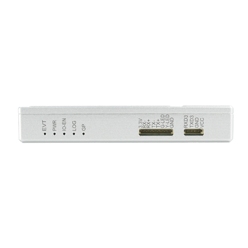
The P-Box-X10 dual-antenna RTK receiver outputs position and heading from a single unit — relevant for docking and lane-keeping tasks in campus logistics. Image: Jumpstar.
Between buildings, sky view is intermittent. This is where inertial bridging becomes part of the specification rather than an optional extra. The JS-RK26-U is a dual-band (L1+L5) GNSS+INS integrated navigation module measuring 16.2 × 12.2 × 2.3 mm and weighing under 1.1 g. Its stated behaviour during GNSS signal loss within 120 s is a positioning error of 5% or less, which keeps a vehicle on a plausible track through a covered transfer corridor until the receiver regains lock.
Scenario B — Precision Robotics for AI-Enabled Automation
AI-enabled automation is shifting robots from fixed cells to mobile platforms: inspection robots patrolling a utility yard, delivery robots moving consumables between buildings, and mobile manipulators that must stop within a known tolerance of a target. These platforms tend to have tight constraints on module size, power and interface count.
Two integration routes dominate. The first keeps the RTK engine as a module inside the robot controller. The JS-SK40 is a high precision RTK GNSS module with 789 hardware super channels, RTK accuracy of 0.6 cm + 0.5 ppm horizontal and 1 cm + 1 ppm vertical, and an RTK initialization time of 7 s at a baseline under 30 km, with a 20 Hz maximum data update rate. The JS-NK40 provides 1408 super channels with RTK accuracy of 1.5 cm + 1 ppm horizontal and 2.0 cm + 1 ppm vertical, an RTK initialization time typically under 5 s, and a 20 Hz update rate.
The second route uses a smart antenna that packages antenna, receiver and, in several models, an inertial measurement unit into one component. The JS-NK43-1 combines multi-band multi-mode RTK positioning with a six-axis IMU (three-axis gyroscope plus three-axis accelerometer, gyro range ±250°/s, acceleration range ±4g). RTK horizontal accuracy is 1 cm + 1 ppm, tracking sensitivity is −166 dBm, and the stated dead-reckoning error is 3% or less of travel distance, with RTK positioning at 20 Hz and IMU output at 50 Hz.
Where heading and attitude must be produced without a magnetometer, dual-antenna smart antennas are the appropriate category. The JS-SK43H-AH is a multi-band RTK positioning and heading smart antenna module with 789 channels, RTK accuracy of 0.6 cm + 0.5 ppm horizontal and 1 cm + 1 ppm vertical, and heading accuracy of 0.15° at a 1 m baseline and 0.03° at a 5 m baseline, in a package measuring 48.0 × 43.2 × 37.0 mm and weighing under 24 g. The JS-RK43-3 provides a smaller dual-band alternative with RTK accuracy of 1.0 cm + 1 ppm horizontal and 1.5 cm + 1 ppm vertical.
For robot developers, the interface set is as important as the accuracy figure. Across these products the common protocol base is NMEA 0183 for position output, RTCM 3.X for differential correction input and output, and a 1PPS signal for time synchronisation — which is what allows a robot's perception stack to timestamp a position against a camera or lidar frame.
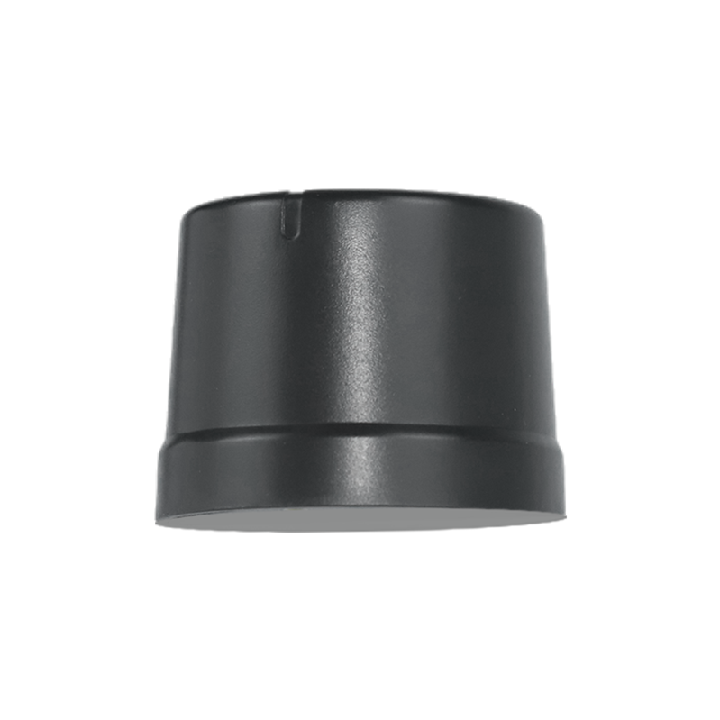
Dual-antenna smart antennas such as the JS-SK43H-AH produce heading as well as position, removing reliance on magnetic heading in electrically noisy environments. Image: Jumpstar.
Scenario C — Outdoor Infrastructure Supporting Semiconductor Logistics
The third scenario sits outside the fab building entirely: yard trucks, tractors, container and material handlers, gate operations and service fleets that connect a semiconductor site to its logistics network. Here the requirements shift toward wide-area coverage, long unattended operating time, and environmental endurance.
The JS-X11 is an all-in-one RTK smart antenna and base station with RTK accuracy of 2 cm ± 1 ppm, PPP accuracy of 50 cm or better in static mode, and velocity accuracy of 0.02 m/s or better. It offers 4G Cat.1 and BLE 5.2 (30 m) communication, accepts 9–45 V DC input, and carries a 5200 mAh 3.7 V backup battery with a working time of up to 10 h. Its IP66 rating, 122 × 122 × 43.09 mm footprint and 375 g weight make it suitable for mast or vehicle mounting, and it supports NMEA 0183, RTCM 3.3/3.2/3.1/3.0 and JT/T808-2013 protocols.
For vehicle-mounted installations, the G27SH-AH is an all-constellation all-frequency GNSS receiver with 789 hardware channels, RTK horizontal accuracy of 0.6 cm + 0.5 ppm, heading accuracy of 0.15° at a 1 m baseline, xPPS timing accuracy of 1.4 ns, and signal latency stated at under 10 ms for 99.9% of transmissions. It carries an IP67 protection level and a built-in TF card slot supporting up to 32 GB, which allows raw observation logging for post-processed trajectory recovery.
The antenna layer is where yard installations most often underperform. Relevant options include the JS-HAC148A quad-system full-frequency RTK surveying antenna, covering 1164–1278 MHz and 1559–1606 MHz with a phase center error of 2 mm or less, amplifier gain of 38±3 dB and an IPX6 rating; the JS-PAS51A-D5 vehicle-mounted antenna covering B1, L1 and L5 with IPX7 protection and a magnetic mount; the JS-HAS67A-D2 dual-band ceramic antenna for B1/L1/L2/G1 with IPX7 protection; and the JS-HAS37 L1/L5 antenna with 28±3 dB LNA gain.
Jumpstar's documented vehicle positioning scenario describes the operating envelope in more concrete terms: onboard RTK rover and roadside static base station modes, an operating temperature range of −40°C to +85°C and storage range of −55°C to +85°C, tolerance of 4g acceleration and 515 m/s velocity, and sustained high-frequency vibration from engine and road surfaces. The scenario's stated special requirements include full multi-constellation multi-frequency reception, built-in anti-jamming, OSNMA anti-spoofing, RAIM integrity monitoring and dual-antenna heading. Supporting equipment listed for the scenario includes a vehicle-mounted autonomous driving domain controller, a GNSS antenna, a 4G NTRIP differential communication module and a TF data storage card. The documented markets for this scenario are China, Japan and Singapore.
In electrically dense yards, the antenna itself becomes an interference-control component. The JS-X168 is a five-array anti-jamming GNSS receiver with an integrated anti-jamming antenna, covering GPS L1/L2/L5, BDS B1/B2/B3, GLONASS G1/G2 and Galileo E1/E5/E6, with a stated anti-jamming capability of 115 dB against a single interference source and 95 dB against three simultaneous sources. Its rated power consumption is 2 W or less at indoor temperature, and it outputs NMEA on one channel and SBF on the other.
Mapping Scenarios to Product Categories
| Scenario | Primary requirement | Matching category | Representative models |
|---|---|---|---|
| Outdoor material transfer between fab buildings | Absolute position plus heading, resilient to interference | Dual-antenna RTK receiver / RTK+INS module | P-Box-X10, JS-RK26-U |
| Compact mobile robot platforms | Small-footprint RTK engine with inertial bridging | RTK GNSS module | JS-ARK37-3, JS-ANK45-2, JS-SK40 |
| Heading in covered or GNSS-degraded zones | Heading and attitude with inertial continuity | RTK+INS smart antenna | JS-NK43-1, JS-CK43-2 |
| Robot heading without magnetic reference | Dual-antenna heading output | Dual-antenna smart antenna | JS-SK43H-AH, JS-NK43-2, JS-RK43-3 |
| Campus and yard fleet operations | Wide-area positioning, base station capability, long autonomy | All-in-one RTK receiver / base station | JS-X11, G27SH-AH |
| Antenna layer on vehicles and masts | Multi-band coverage, stable phase centre, weather sealing | GNSS antennas | JS-HAC148A, JS-PAS51A-D5, JS-HAS67A-D2 |
| High-interference electrical environments | Interference rejection at the RF front end | Anti-jamming antenna | JS-X168 |
Market Trend Analysis: What the Published Data Shows
Third-party market data places high precision GNSS in a sustained expansion phase. Dataintelo valued the global high precision GNSS market at USD 7.8 billion in 2024 and projected it to reach USD 20.6 billion by 2033. Market Research Future estimated the high precision GNSS module segment specifically at USD 1.5 billion in 2024, forecast to reach USD 4.5 billion by 2035. At the downstream level, EUSPA has forecast GNSS downstream market revenues of €580 billion by 2034.
These figures should be read with care. The same source set shows material divergence: Dataintelo's USD 7.8 billion for the high precision GNSS market in 2024 sits alongside a MarketsandMarkets figure of USD 3.41 billion for the mid and high-level precision GPS receiver market in the same year. The difference reflects scope — receivers alone versus receivers plus associated solutions — rather than disagreement about direction. Any single headline number is therefore less informative than the trend it describes.
The more useful signal is where demand concentrates. Agriculture held a 36.8% share of high precision GNSS applications in 2025, and the precision farming market itself was projected by MarketsandMarkets to grow from USD 11.38 billion in 2025 to USD 21.45 billion by 2032. Agriculture is the vertical in which high precision GNSS is fused to automated machinery at scale. The pattern — positioning value scaling with the density of automated mobile equipment — is the relevant one for semiconductor fabrication and robotics planners, because those environments are following the same path of replacing fixed guidance with software-defined movement.
Two technology trends are visible in the same data set. First, inertial integration is becoming a standard feature of precision positioning products rather than an accessory: Trimble launched the R12i GNSS System in 2024 with IMU technology integrated for enhanced RTK performance. Second, standardisation is catching up with automation — ISO 12188 parts 1 and 2 define test procedures for positioning and guidance systems in agriculture and forestry, and the Galileo High Accuracy Service is specified to deliver horizontal accuracy down to 20 cm for autonomous farming and high-precision mapping. Both indicate that guidance-grade positioning is being treated as a measurable, testable engineering discipline.
The competitive structure is relevant to buyer planning. Mordor Intelligence identifies Trimble, Hexagon AB, Topcon and Hemisphere GNSS as leading players in the mid and high-level precision GPS receiver market. Source manufacturers such as Jumpstar occupy a different position in that structure, supplying modules, antennas and integrated receivers to integrators and OEMs. Jumpstar reports that exports account for 70% of its total sales, with major markets in the European Union, the United States and the Middle East, and holds ISO 9001:2015 certification issued by Beijing United Intelligence Certification Co., Ltd. under certificate number UQ231801R2, applicable to the EU market.
GNSS RTK Versus Traditional Positioning Approaches
GNSS RTK rarely replaces an existing positioning method outright. In most fab and robotics projects it occupies the segments where the incumbent method is weakest.
| Approach | Reference frame | Route infrastructure | Notable strength | Notable constraint |
|---|---|---|---|---|
| Total station / laser tracker | Local, site-defined | Line of sight to targets | Very high precision over short ranges | Requires line of sight and periodic re-setup; coverage is constrained by geometry |
| Magnetic tape or QR-code grid AGV guidance | Fixed path | Physically installed per route | Robust and well understood indoors | Any route change is a physical construction task |
| Encoder and inertial odometry | Relative to start point | None | No external infrastructure required | Error accumulates with distance and needs an external reference to re-zero |
| GNSS RTK | Absolute, global | Correction link only | Wide-area absolute positioning with heading in dual-antenna form | Requires sky visibility and a live correction source |
Limits and Boundaries Buyers Should Plan Around
An honest GNSS specification acknowledges what the technology does not do. The following boundaries are drawn from the product parameters and operating scenarios themselves rather than from marketing claims.
- Sky visibility is a precondition. GNSS RTK is an outdoor and open-area technology. A cleanroom with metallic shielding and dense process equipment is not a GNSS environment, and no receiver specification changes that. Indoor segments require a different localisation layer, with GNSS resumed outdoors.
- Real-time kinematic positioning depends on a correction source. RTK requires correction data from a base station or network service, carried over 4G, radio or another link. The documented fleet scenario lists a 4G NTRIP differential communication module among its supporting equipment for exactly this reason. Without correction data, the receiver falls back to standalone accuracy.
- Accuracy figures carry conditions. The JS-SK40 specification, for example, states its 0.6 cm + 0.5 ppm horizontal figure for 24-hour static operation with at least 15 satellites. Field performance in a moving vehicle, under partial sky view, will differ from a static test figure.
- Accuracy scales with baseline. The ppm term in every RTK specification is not decorative; it grows with the distance between rover and base. Site design — where base stations are placed — directly affects achievable accuracy.
- Inertial bridging has a time window. Dead reckoning holds accuracy for seconds, not minutes, before degrading. The S-C8A's stated behaviour of centimetre-level performance at 3 s of lock loss and metre-level at 10 s is the clearest illustration of this boundary.
- Interference and spoofing are real operating conditions. This is why product documentation lists AIM+ anti-jamming, OSNMA anti-spoofing, IONO+ mitigation, APME+ multipath suppression and RAIM integrity monitoring as named functions, and why dedicated anti-jamming antennas such as the JS-X168 exist as a separate product category.
- Antenna installation quality sets the ceiling. Phase centre stability, mounting plane and cable routing affect results as much as receiver choice. The JS-HAC148A's stated phase centre error of 2 mm or less is a specification that only matters if the mounting preserves it.
Future Outlook
Three developments appear likely to shape how these scenarios are specified over the next several years.
First, GNSS and inertial fusion will continue to move from optional to expected. Products such as the JS-NK43-1, JS-CK43-2, JS-RP26-U and JS-TP26-U already integrate inertial sensing with GNSS positioning, and competitor product development has moved in the same direction. For buyers, this means the practical question shifts from "does the module support RTK" to "what is the dead-reckoning error over the specific tunnel, canopy or corridor on my site".
Second, anti-jamming and anti-spoofing are becoming baseline requirements rather than premium options. As more industrial decisions are made automatically from positioning data, the integrity of that data becomes an operational risk question. The presence of OSNMA anti-spoofing and RAIM integrity monitoring in production GNSS receiver specifications, and of dedicated multi-array anti-jamming antennas on the market, reflects that shift.
Third, dual-antenna heading is displacing magnetic heading in electrically noisy industrial settings. Magnetometer-based heading is vulnerable to the ferrous structures, motors and cabling found on industrial vehicles; dual-antenna heading derives orientation from the satellite geometry itself. As more platforms specify heading accuracy in tenths of a degree, the antenna configuration on the roof starts to matter as much as the receiver inside.
Underneath all three, the supply side is consolidating around manufacturers who can combine design capability with production capacity and certification. Jumpstar's position — a 5,000 m² facility, a 20-engineer R&D team, 100,000-unit annual capacity, ISO 9001:2015 certification, and a 70% export share concentrated in the EU, the USA and the Middle East — illustrates the profile that semiconductor and robotics supply chains tend to require from a positioning component partner.
Frequently Asked Questions
What is a GNSS RTK receiver, and what does centimetre-level mean in practice?
A GNSS RTK receiver is a device that determines position by combining satellite signals with real-time correction data from a base station or network service. “Centimetre-level” is a specification with conditions attached: the P-Box-X10, for example, states RTK horizontal accuracy of 0.6 cm + 0.5 ppm, and the JS-SK40 states 0.6 cm + 0.5 ppm horizontal under 24-hour static conditions with at least 15 satellites. The ppm term means the figure degrades as the distance between rover and base increases.
Can GNSS RTK positioning work inside a semiconductor cleanroom?
No. GNSS requires sky visibility, and a cleanroom with metallic shielding and dense process equipment blocks satellite signals. GNSS RTK is appropriate for fab campuses, yards, docks, perimeter roads and other outdoor or semi-covered areas. For indoor segments, an inertial module can bridge a signal gap for a limited period — the JS-RK26-U, for example, holds positioning error to 5% or less within 120 s of GNSS loss, while the S-C8A is stated at centimetre level for a 3 s loss of lock and metre level at 10 s — but a separate indoor localisation layer is required for the cleanroom itself.
For an autonomous mobile robot, should an integrator choose a receiver, a module, or a smart antenna?
The choice depends on how much of the RF and mechanical design the integrator wants to own. A GNSS RTK receiver such as the P-Box-X6_Pro S is a complete unit that mounts on the platform. An RTK GNSS module such as the JS-M6D or JS-ARK37-3 is integrated into the robot's own board and enclosure. A smart antenna such as the JS-NK43-1 or JS-SK43H-AH integrates antenna, receiver and, in some models, an IMU into a single drop-in part. Modules suit high-volume custom platforms; smart antennas suit teams that want one integration surface and a defined RF assembly.
How do dual-antenna heading and IMU dead reckoning differ in robotics navigation?
They solve different problems. Dual-antenna heading derives orientation from the geometric relationship between two antenna positions, so it does not depend on the Earth's magnetic field; the JS-SK43H-AH states heading accuracy of 0.15° at a 1 m baseline and 0.03° at a 5 m baseline, and the P-Box-X10 and G27SH-AH state the same figures. IMU dead reckoning maintains a position estimate when satellite signals are interrupted; the JS-NK43-1 states a dead-reckoning error of 3% or less of travel distance, and the JS-CK43-2 states 3%d. Heading technology and inertial bridging are complementary, and some platforms need both.
Which GNSS antennas are used for outdoor semiconductor logistics vehicles?
Vehicle and yard installations generally use multi-band active antennas with weather sealing and a stable phase centre. Jumpstar's relevant models include the JS-HAC148A quad-system full-frequency RTK surveying antenna covering 1164–1278 MHz and 1559–1606 MHz with phase centre error of 2 mm or less and an IPX6 rating, the JS-PAS51A-D5 vehicle-mounted antenna covering B1/L1/L5 with IPX7 protection and a magnetic mount, the JS-HAS67A-D2 dual-band ceramic antenna covering B1/L1/L2/G1 with IPX7 protection, and the JS-HAS37 L1/L5 antenna with 28±3 dB LNA gain. In high-interference yards, an anti-jamming antenna such as the JS-X168, specified at 115 dB rejection against a single interference source, may be appropriate.
What should a buyer verify before selecting a high-precision GNSS supplier?
Four verification areas matter more than headline accuracy. First, whether accuracy figures are stated with conditions — static or dynamic, satellite count, baseline distance. Second, whether the supplier owns both the receiver and the antenna layer, since antenna quality sets the achievable ceiling. Third, whether the products carry documented environmental ratings such as IP66, IP67 or IPX6, and temperature ranges such as −40°C to +85°C. Fourth, whether the supplier holds quality certification; Jumpstar's GNSS RTK Receiver product is certified to ISO 9001:2015 under certificate number UQ231801R2, issued by Beijing United Intelligence Certification Co., Ltd. and applicable to the EU market.
Jumpstar's full product and capability listing, including module, antenna and receiver specifications, is available in the company profile PDF: Jumpstar company profile 2026.